


Naming waterscapes in Culatra
Naming waterscapes in Culatra
Glossary
Knowledge of the world is gained by moving about in it, exploring it, attending to it, ever alert to the signs by which it is revealed.
Tim Ingold, The Perception of the Environment, 2000, p.55
Going to the tide, or Ir à maré in Portuguese, happens cyclically every day. The tides are calculated by the Hydrographic Institute, which is part of the Portuguese Navy, and tide tables can be found at the Associação de Moradores da Ilha da Culatra (Culatra Island Residents’ Association) every month. Some prefer it on paper. Others follow internet sites and apps. Fishing activities and, particularly, oyster farming and shellfish gathering become visible and take place at low tide. A couple of hours before the ebb tide (and, sometimes, a few hours after the tide reaches its lowest limit), the mariscadoras (here I use the Portuguese term for female shellfish gatherers) cross the streets of Culatra wearing their work clothes: water shoes, a brimmed hat, training suit trousers or shorts (depending on the season), and carrying their tools: a small basket made by a local craftsman and a knife for digging (the Portuguese verb for this is cavar, meaning to dig, the same word used in agriculture). People ask, “Are you going to the tide?” meaning, are you going out to harvest for clams? The answer can come with some joke or a quick comment like “É assim a vida” (“That’s the way life goes”).
The path to the commons extends across the Ria Formosa, towards the sandbanks, lying to the east of the village. I use here the term commons because these are the sandbanks where everyone can gather shellfish, unlike the clam nurseries scattered throughout all over the water. The not so old but already very badly deteriorated bridge built by locals to facilitate the crossing of a small stream – water goes in and out of the Recovo, a small bay - is now a reason for complaint. Crossing the bridge has become very difficult. Women warn each other about the best place to cross. They spread sand on the wooden planks to prevent slipping. In summer, crossing the stream can be easy, but in winter it can be cold. Currents are strong. Because this is an ecological reserve, the Natural Park does not allow the construction of any bridge at all. Yet, this bridge was built by local people to help working women gather shellfish.
Muddy sandbanks and brackish smells. The sound of water shoes walking over the marshy sand. We arrive at Cabeça do Meio (“Head in the Middle” or “Middle Head"). Salesia, a seventy-year-old woman and one of my dear interlocutors, indicates where we should dig. She brought a small bucket for me. She starts to dig. And she explains to me: “Can you see the little “eye” in here? That’s where you should dig.” She turns over the mud with her knife while gathering the first clams that show up. I can’t see any “eye”. I only see different shades of brown and grey mud. We spend around three hours there, moving around looking for clams, leaving a trail of footprints and holes behind. Looking at the horizon, I can see the silhouette of people scattered across the horizon. Curved bodies digging in the mud. This Herculean effort will, some hours later, be transformed into a delicious dish: amêijoas à bolhão pato. A hard job which younger people are reluctant to take up. Contrarily to older women with physical limitations who cannot “go to the tide” but who miss it. When their bodies can no longer bend – because of their back, legs or knees – doctors advise them not to go. “Going to the tide” is not only about work. It is about laughing with others. A little bit of gossip. “Clear our heads”, as Salesia tells me. Waterscapes socialize people into their world of references – friends, family, and alike. When older women are no longer able to go, an important part of their lives is transformed.
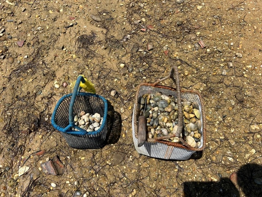
Salesia fills a bucket with clams. I am not so skilled. Cabeça do Meio (the “Head in the Middle”) is the local term used to describe one of the sandbanks where women gather clams and shellfish in general. But many others exist. Sciaena, our Liminal Waterway Countercultures partner, the non-governmental organization dedicated to promoting a healthy marine environment, led a project aimed at strengthening the role of Culatra’s women in biodiversity. Mulheres da Ria (Ria Women) was funded by Fundação Calouste Gulbenkian and aimed to reinforce women’s role in the conservation of seagrass meadows in the Ria Formosa lagoon, particularly in the Recovo. While visiting women at their own working sites, Sciaena biologist Valentina Muñoz understood that women used vernacular names to describe the waterscapes intimately linked to their daily work activities. Sciaena later transformed these vernacular names into a map.
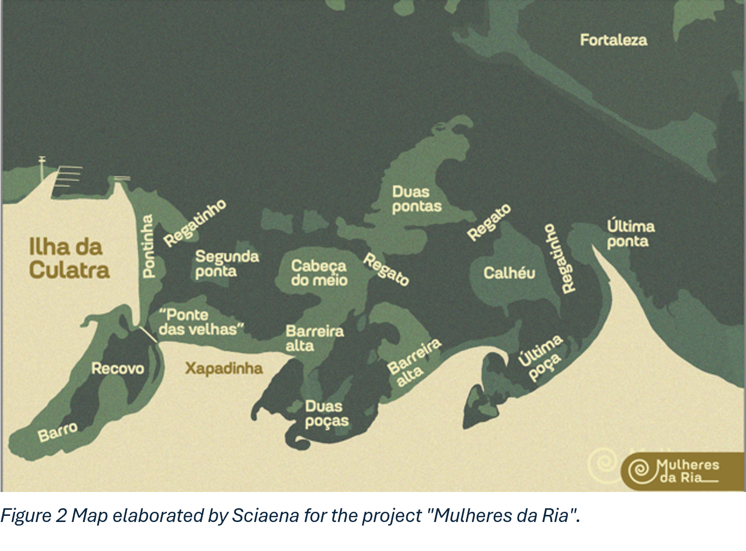
Names describe sandbanks and puddles: The bridge is called “Ponte das Velhas”: “Old women’s bridge”, showing who are the ones who use the bridge. Gender organizes work in the village. Then, “a última ponta” or “the last tip”, the furthest sandbank that can be reached on foot. On the other side of the canal lies the Fortaleza, or Fortress, that indicates the existence of the Forte de São Lourenço. The Algarve Coast was exposed to piracy during many centuries, and, in 1707, several fortresses in Ria Formosa were armed with artillery and garrisoned. According to a military document, the Forte de São Lourenço was destroyed in 1821, as a result of sea erosion (Magalhães in Godinho 2001:101).
In Culatra, dunas (dunes) are cerros (hills) because everything is flat and dunes are an elevation on the horizon. The ria (the feminine of rio, river), described in the Portuguese dictionary “as a small arm of the sea that, in the shape of a bay, penetrates inland from the coast”, that gives its name to the Natural Park of Ria Formosa, is always the sea (the “inside sea” in contrast to the “outside sea”, “O mar lá fora”, the Atlantic Ocean). These two seas are recognizable by their temperament: the inside one is calmer and safer; the outside one is more uncertain and sometimes furious. Those frightening sea stories told by the people of Culatra often take place in the inlets, the liminal spaces between the inside and outside seas, where the currents are strong, sandbanks move from day to night, and winds can change in seconds.
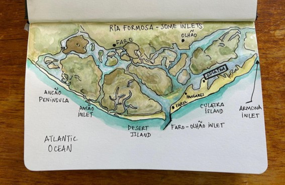
Those inlets, or barras, have many names too. Culatra island extends across 6 km, separated from other islands by two inlets: the Faro-Olhão Inlet (Barra de Faro-Olhão) and the Armona inlet (Barra da Armona). The Faro-Olhão it is also locally known as New Inlet (Barra Nova), or, Junot Inlet (Barra de Junot), in reference to the French General Jean-Andoche Junot who led the first French Invasion of Portugal in 1807. Olhão, now the mainland city, at the time a village, was an important centre of resistance to the French. Names also indicate the history of places. The Faro-Olhão inlet was artificially opened between 1929 and 1955, at that time a new and important asset for navigation. Its opening ensured navigable depths in access channel leading to the two main cities, as it has been demonstrated by several oceanographers of the University of Algarve (cf. Pacheco et al. 2008). The Armona inlet is a natural one, located at east of the Culatra island, and separates Culatra from Armona. Fishermen in Culatra refer to this inlet as the Big Inlet (Barra Grande) or Lavajo Inlet (Barra do Lavajo). According to the map of toponomy of the Algarve seas “Toponímia dos Mares Algarvios”, a result of a research project led by the University of Algarve, the term Limpo Lavajo describes the sea in front of Culatra Island. Lavajo does not have a concrete meaning in standard Portuguese. On the “inside sea”, the small bay in Culatra is the Recovo. It sounds like a comfortable and protected space, although in archaic Portuguese it means “the act of leaning on one's elbow” (cf. Priberam Dictionary).
Naming can be an emotional political act. Localisms and regionalisms serve to defy official names. They express autochthony, resulting from a culturally constituted relationship with the characteristics of water, the sea, the mud, the sandbanks and everything else. Sea cultures emerge through repetition, recognition and differentiation from the land and waterscape – the everyday appropriation of the environment. In the introduction to the issue “Dénominations plurielles. Quand les noms de lieux se concurrencent”, in EchoGéo journal, the geographer Frédéric Giraut affirms that “naming places is indeed an essential human operation of territorialization, at the very core of political geography” (2020:53). Often concealed by official names, vernacular naming constitutes a form of affective connection that is political. When political authorities and scientists argued that the village of Culatra should be demolished, because it was illegal, the people of Culatra argued that they were not invaders or aliens. Their attachment to the place emerged through the waterscapes: a knowledge of the tides, currents, birds, fish and molluscs, based on repetition, rather than decisions made in offices. Those names are not displayed in official maps of the Ria Formosa, in tourist brochures or scientific reports. Instead, they are “on the tip of Culatrenses' tongue" anchoring knowledge in place.
In the International Encyclopaedia of the Social and Behaviour Sciences, the Portuguese anthropologist João de Pina-Cabral argues, in the “Names and Naming” entry, that personal naming constitutes a central aspect of human sociality and is “self-building a condition for language and a result of language. People start working on their own personhood as they enter language.” (2015:183). In a game between the others and I, personal names tell us how societies negotiate that tension between plurality (always anterior in the sense that humans enter in a world previously inhabited by others) and singularity (never totally achieved and always in construction) through language. Vernacular names of waterscapes do not just describe places; they become the language through which the people of Culatra recognize and interpret what is around them. This is the language that enables ethnographers to move beyond their own perception of what is a waterscape and to step on their interlocutors’ experience of the world. From that day on, we started a conversation and shared something. I could not see the “eye” in the grey mud. However, I do now know that the mud has an “eye”. The “eye” from which the clams breathe.
Many thanks to Diana Lixandru for proofreading the text into English.
---
Coutinho, Valdemar. 2001. Dinâmica Defensiva da Costa do Algarve. Do período Islâmico ao século XVIII [Defensive Dynamic of Algarve Coast. For Islamic period until the 18th century]. Portimão: Instituto de Cultura Ibero Atlântica
Giraut, Frédéric. 2020. “Dénominations plurielles: quand les noms de lieux se concurrencent!”, EchoGéo, 53 | 2020. DOI: doi.org/10.4000/echogeo.20167
Pacheco, A. A. Vila-Concejo, Ó. Ferreira, J.A. Dias. 2008. “Assessment of tidal inlet evolution and stability using sediment budget computations and hydraulic parameter analysis”, Marine Geology, Volume 247, Issues 1–2:104-127,
Pina-Cabral, João de. 2015. “Names and Naming”. In J. D. Wright (editor-in-chief), International Encyclopedia of the Social & Behavioral Sciences, 2nd edition, Vol 16. Oxford: Elsevier. pp. 183–187.
Date: 31. 7. 2026.